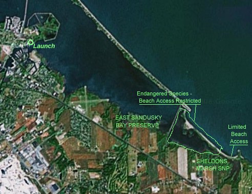
Big Island Canoe Launch
Sandusky, Ohio
updated Aug 20, 2007

| The City
of Sandusky East Sandusky Bay Water Trail was officially dedicated
here on June 2, 2007. This is the best available kayak/canoe access
within this
beautiful, three-mile
long, very shallow section of Sandusky Bay and the East
Sandusky Bay Water Trail. (At this time, other public sites
are few and obscure and/or offer poor or no launch access.) Only
human-powered craft will be permitted to use this launch, we
understand. Improvements here began only recently and are ongoing. The narrow gravel beach has not been completely cleared. Beware of unknown hazards here. This is no place for bare feet!  Immediately off
the lauch is a marked
channel where powerboat move pretty fast
but, the rest of this part of the Bay is too shallow to be used
by most powered craft. Immediately off
the lauch is a marked
channel where powerboat move pretty fast
but, the rest of this part of the Bay is too shallow to be used
by most powered craft. In the view above, you're just 100 feet or so from the Pipe Creek Wildlife Area parking lot, looking East. Approximately two miles distant, Erie Metroparks has recently added several new preserves, including Eagle Point, Steinen Wildlife Area, and Putnam Marsh. Their website includes additional information and a map. At least two Bald Eagle nests can be clearly seen from the Bay, but getting too close during nesting season (January through July) will get you a hefty fine or jail time. Sheldon Marsh State Nature Preserve lies beyond. |
You can even get an on-line NOAA nautical chart that includes the lauch area.

click for an MSN Maps Interactive Map
For more Sandusky Bay resources, visit SAILSANDUSKY.COM